Stand in Crestline Park and look north at the wooded ridge above Montclair Road. It is about the quietest thing in the neighborhood now. A hundred and sixty years ago it was the loudest place for miles. The whole south face of that mountain was being dug, blasted, stripped, and hauled away, one mule-drawn tram car at a time.
Let's get the geography honest first. The mines themselves sit technically in the adjacent Crestwood neighborhood, strung along Red Mountain just north of Montclair Road. Their story ran downhill through here, though. The ore came off that ridge on wooden tramways that cut through what is now Crestline Park, headed for a blast furnace on Shades Creek just downstream in Cherokee Bend.
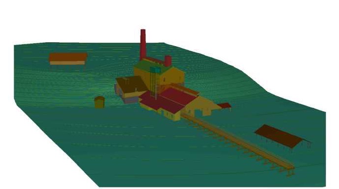
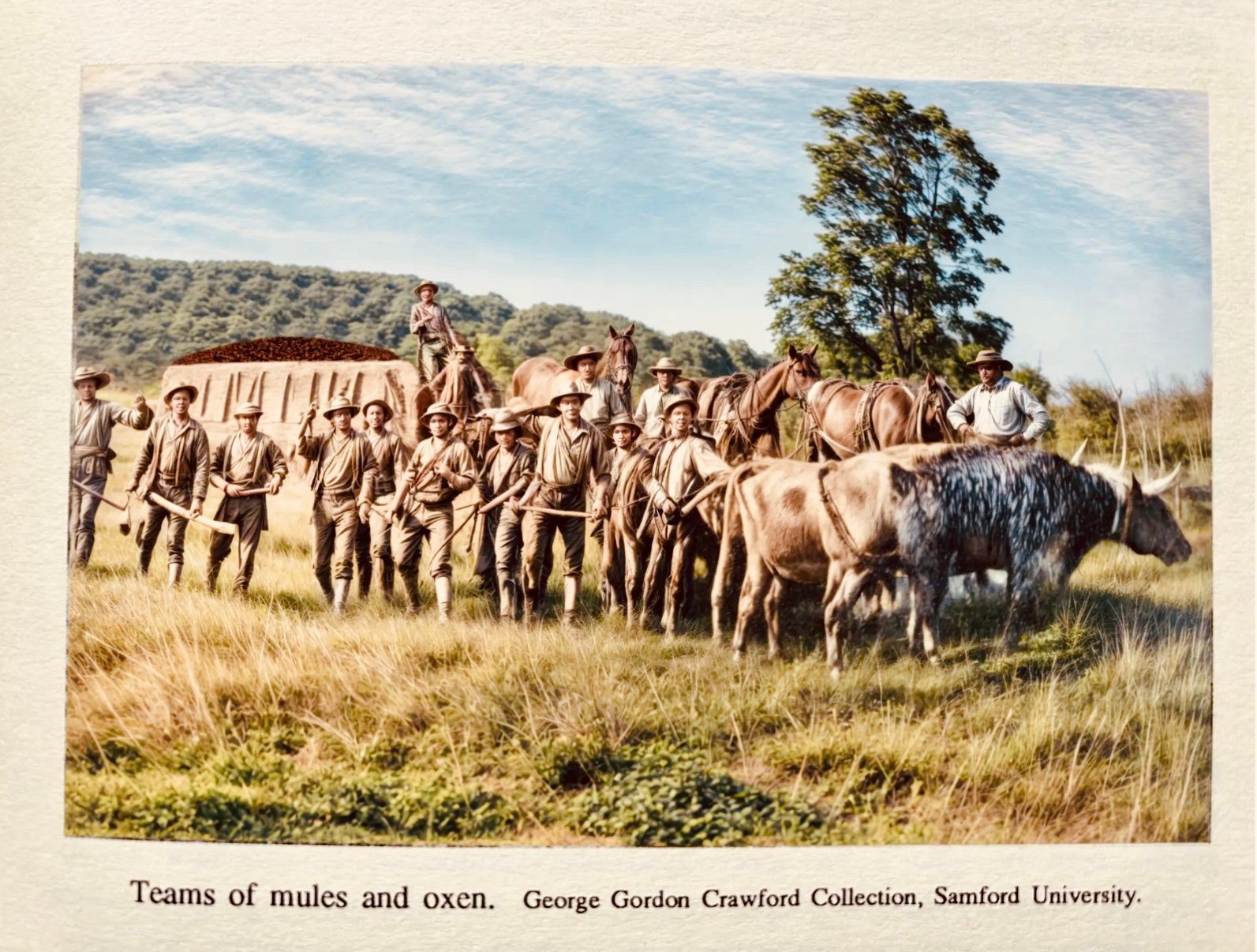
It started with a man running from one war and straight into the middle of another. Wallace S. McElwain, a New York-born machinist and foundryman, was casting arms for the Confederacy at Holly Springs, Mississippi, when Union forces got too close. He scouted Jefferson County for safer ground, and in February 1863 he secured land from Willis Eastis and built the Cahaba Iron Works on Furnace Creek, a branch of Shades Creek. His partners were Eliza G. Barney and W. A. Jones. Everybody just called it the Irondale Furnace. The operation eventually covered more than two thousand acres: ore mines, a limestone quarry, a brownstone quarry, tramways, a foundry, blacksmith shops, stables, and housing for some five hundred workers. Most of those workers, as historian Marilyn Davis Barefield recorded, were enslaved men. During the war the pig iron went by ox wagon to the railhead and on by rail to the Confederate arsenal at Selma.
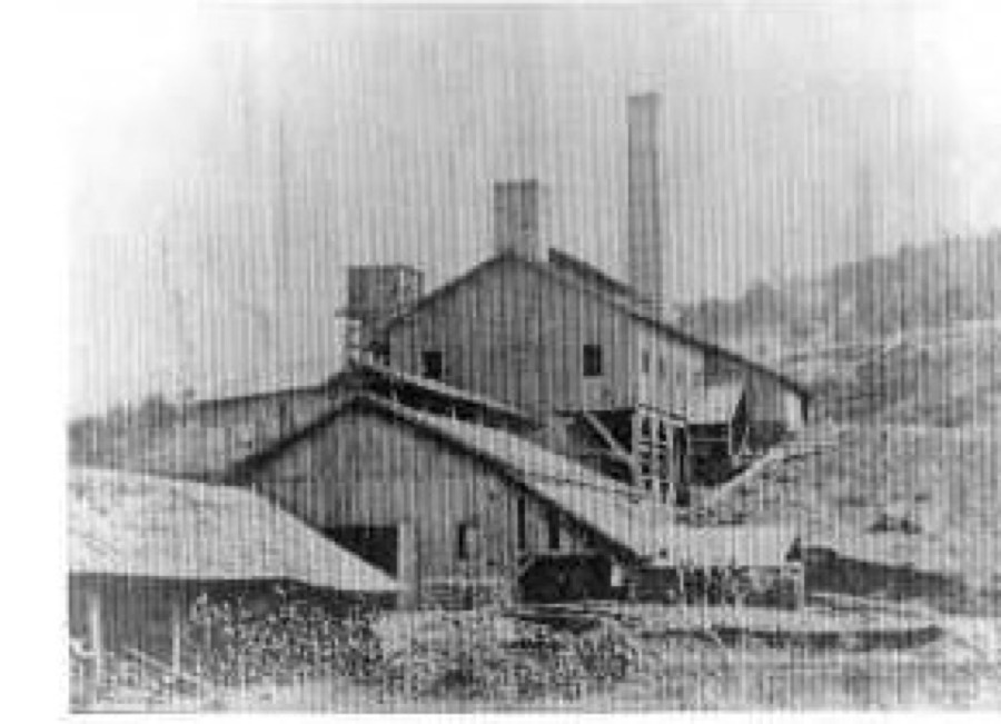
Here is the part almost nobody knows. In 1863 the furnace began experimenting with coke in place of charcoal, and by early 1864 it was successfully making coke pig iron. That was some of the first ever produced in Alabama, roughly a decade before the celebrated experiments that historians usually credit with launching Birmingham's coke-iron future. The industrial revolution that built this city ran its first trials on Shades Creek, within earshot of our neighborhood.
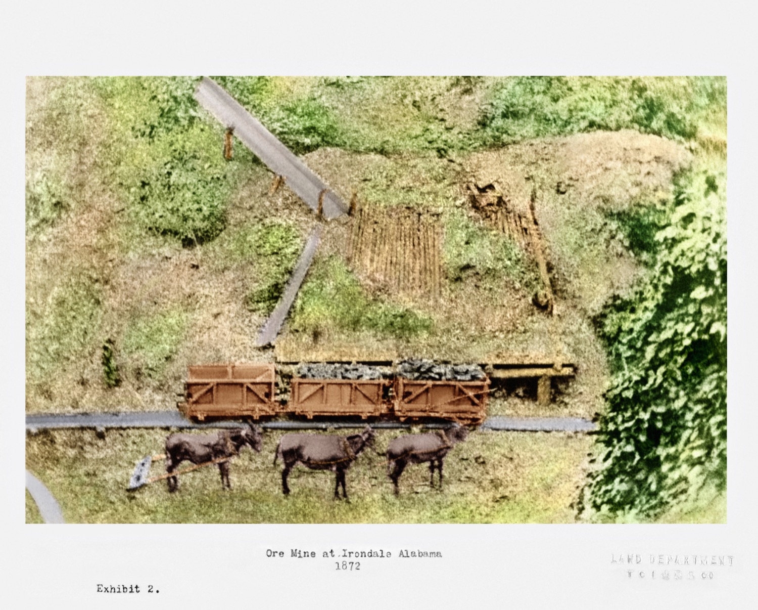
For over a century, histories going back to Ethel Armes claimed McElwain's ore came from the Helen Bess mine. Robert Yuill and Barefield proved otherwise. His mines were in the ravine between 52nd Street and Art Hanes Boulevard, just east of the old Trinity Montclair hospital site. Sixteen drift mines opened off that one ravine, and the old tramway grade is still visible today in the backyards along Art Haines Circle. The tramways were built of pine rails, and they ran on mules and gravity. Loaded cars rolled downhill to the furnace, and the mules hauled the empties back up.
You can walk the main tram route today without leaving the neighborhood, because our streets were laid down on top of it. The line came out of the mine ravine between 52nd Street and Art Hanes Boulevard and merged onto Montclair Road. It turned south on Beach Circle, followed the creek between two houses across Beach Street, and kept along that creek down Leach Drive and Kingsbury Drive toward the furnace. Three separate land deeds record the Iron Works tram road passing exactly there, and the route matches the creek that feeds Shades Creek from the north. A second tramway served the workings farther east near today's Eastwood Festival Center. It ran along Cresthill Road on what later became the mineral railroad's route, curved along Montclair, and turned at Hagood to meet the first line near Crestline Park. From there it was downhill to Cherokee Bend. So when you turn off Montclair onto Beach Circle, or follow Leach Drive along the creek, you are driving the ore road, grade and curves and all.
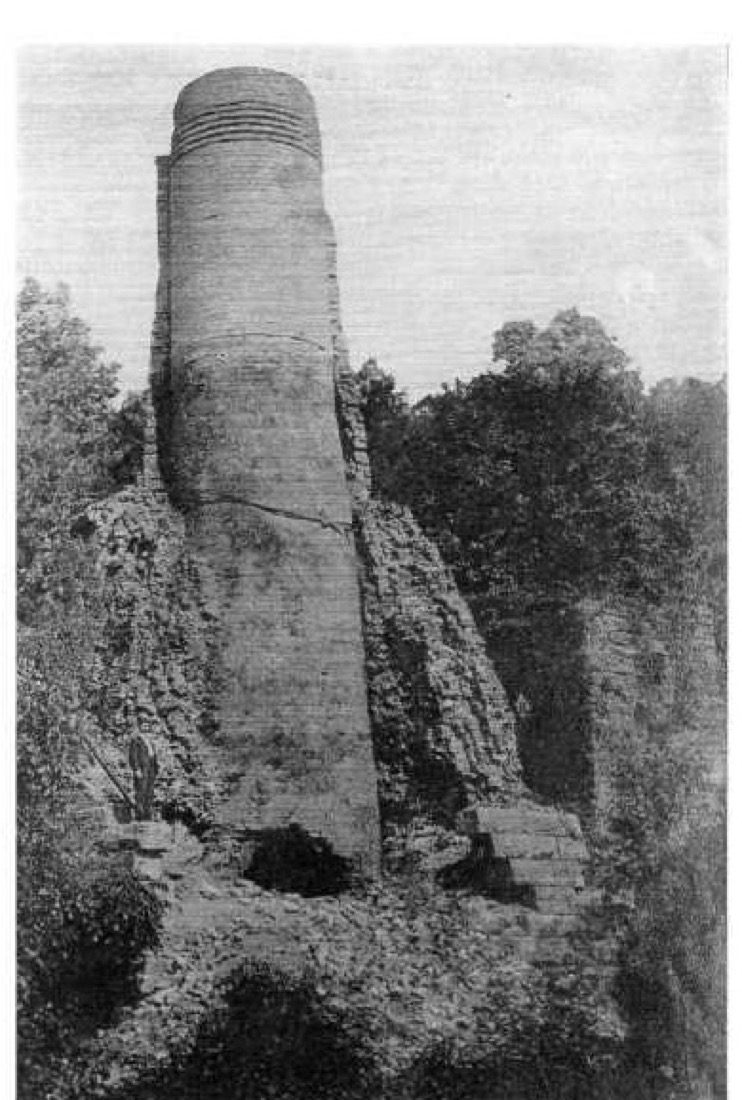
On March 30, 1865, Wilson's Raiders found it all. A detachment of the Fourth Iowa under General Emory Upton spent the day breaking the entire McElwain operation, from the drift mouths on the mountain to the furnace stack itself, tearing up the wooden tramways as they went. They spared exactly one building: the commissary, which they were using. Barefield wrote that the enslaved workers undoubtedly welcomed the soldiers as saviors. That spared commissary still stands today. Neighbors know it as the Cummings-Eastis House, and it sits within a hundred feet of the creek the old tram road followed.
McElwain wasn't finished. He went to Cincinnati, came back with financing from A. D. Breed, and by early 1866 the Irondale Furnace was back in blast, the first furnace in Alabama to return to operation after the war. It made pig iron and castings, farm implements, and cast parts for the railroads. In 1871 the property was leased to the Thomas family interests of Catasauqua, Pennsylvania, the most famous ironmasters in America, and James Thomas rebuilt the furnace in 1872, roughly tripling its capacity. Then the Panic of 1873 hit, the lease was cancelled that May, and the operation wound down for good. In December 1874 the company's mules were advertised for sale in the Birmingham Iron Age. That mule ad is, more or less, the furnace's obituary. By 1877 the machinery had been carted off to other furnaces.
But the furnace never really left. Its workers' families founded Irondale Methodist Church in 1867, and in 1874 a Methodist bishop presided over a conference held inside the furnace's machine shop. That congregation became Union Hill, and eventually Canterbury United Methodist in Mountain Brook. The town of Irondale, incorporated in 1887, took its name from the furnace, though the furnace itself sits across the mountain in present-day Mountain Brook. Even the geology remembers. Of the three ore seams in this stretch of Red Mountain, the Irondale seam is named for the furnace's mines, and the Ida seam is named for Ida McElwain, the ironmaster's daughter. The families who worked that first operation buried their dead on a hillside along Gladstone Avenue, at McElwain Cemetery, the next story in this series.
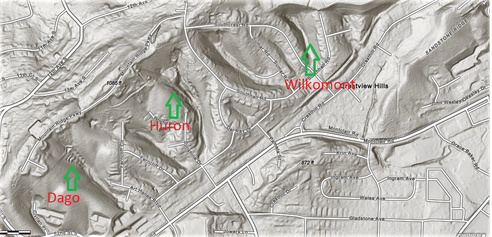
The second mining boom came by rail. In 1884 the Louisville & Nashville opened the Birmingham Mineral Railroad, and its ten-mile Red Gap Branch ran spurs into the ravines all along the ridge. The names from that era still show up on the old maps. The Dago mine occupied Dago Hollow, bought in 1868 by Pennsylvania ironmaster Samuel Thomas on one of his first trips south. His Pioneer Mining and Manufacturing Company ran a rail spur into the ravine in 1889 and mined there from 1890 to 1900. By 1935 a Republic Steel report noted the property had "greater real estate value than ore value," and looking at the houses there now, they weren't wrong. The Huron worked the next ground east. The Wilkomont, a name the railroad itself gave the place, was leased in 1892 by G. L. Morris and T. T. Hillman (the same iron man whose Alice Furnace figures in the Ghost on Jowers Lane) to a contractor named C. M. Morgan at a royalty of twenty-five cents a ton. Gate City's newspaper, the Humming Bird, declared on its front page that Morgan's new opening "bids fair to be the greatest success of the age," and by that September he was "running his mines on a boom."
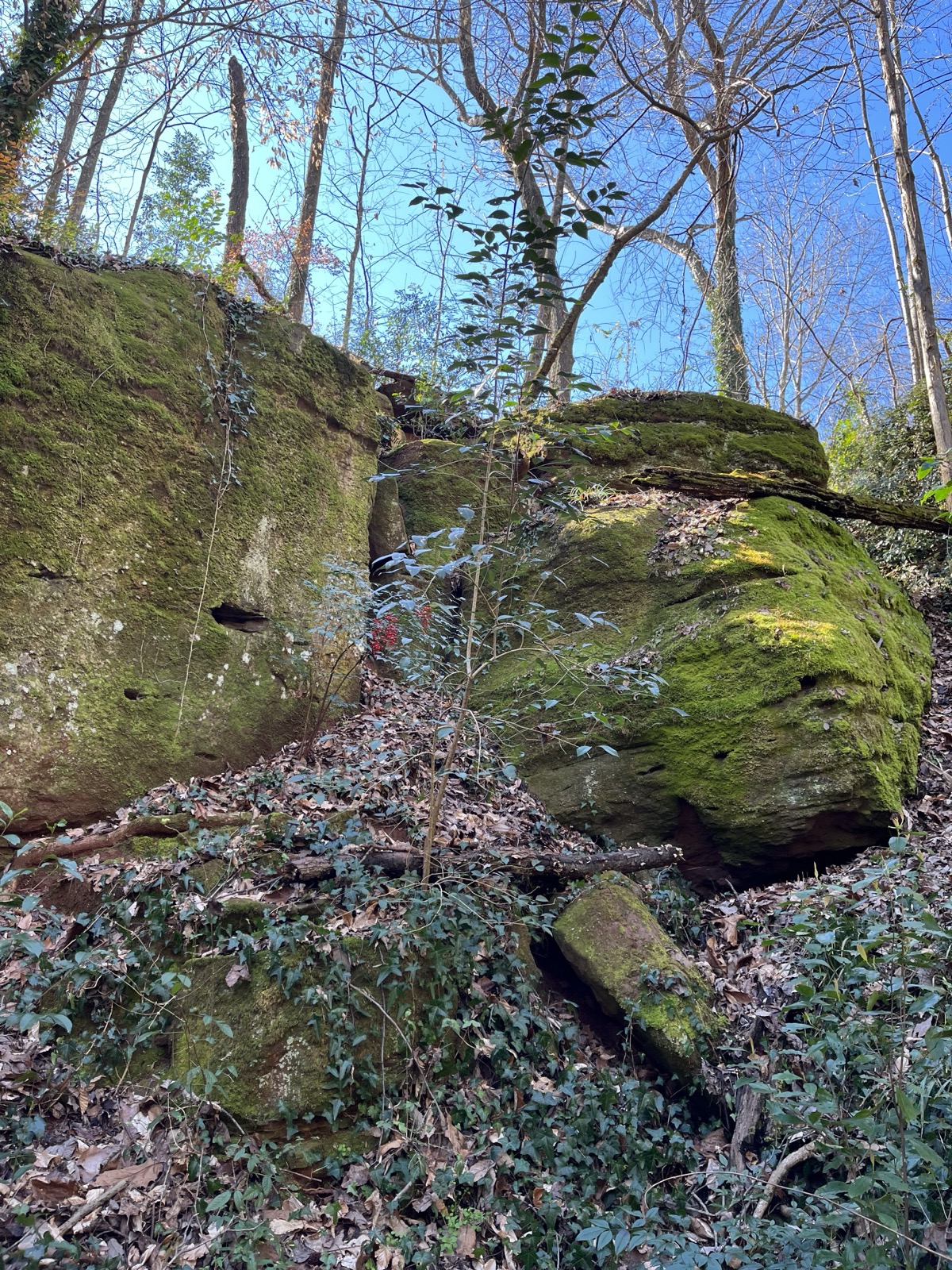
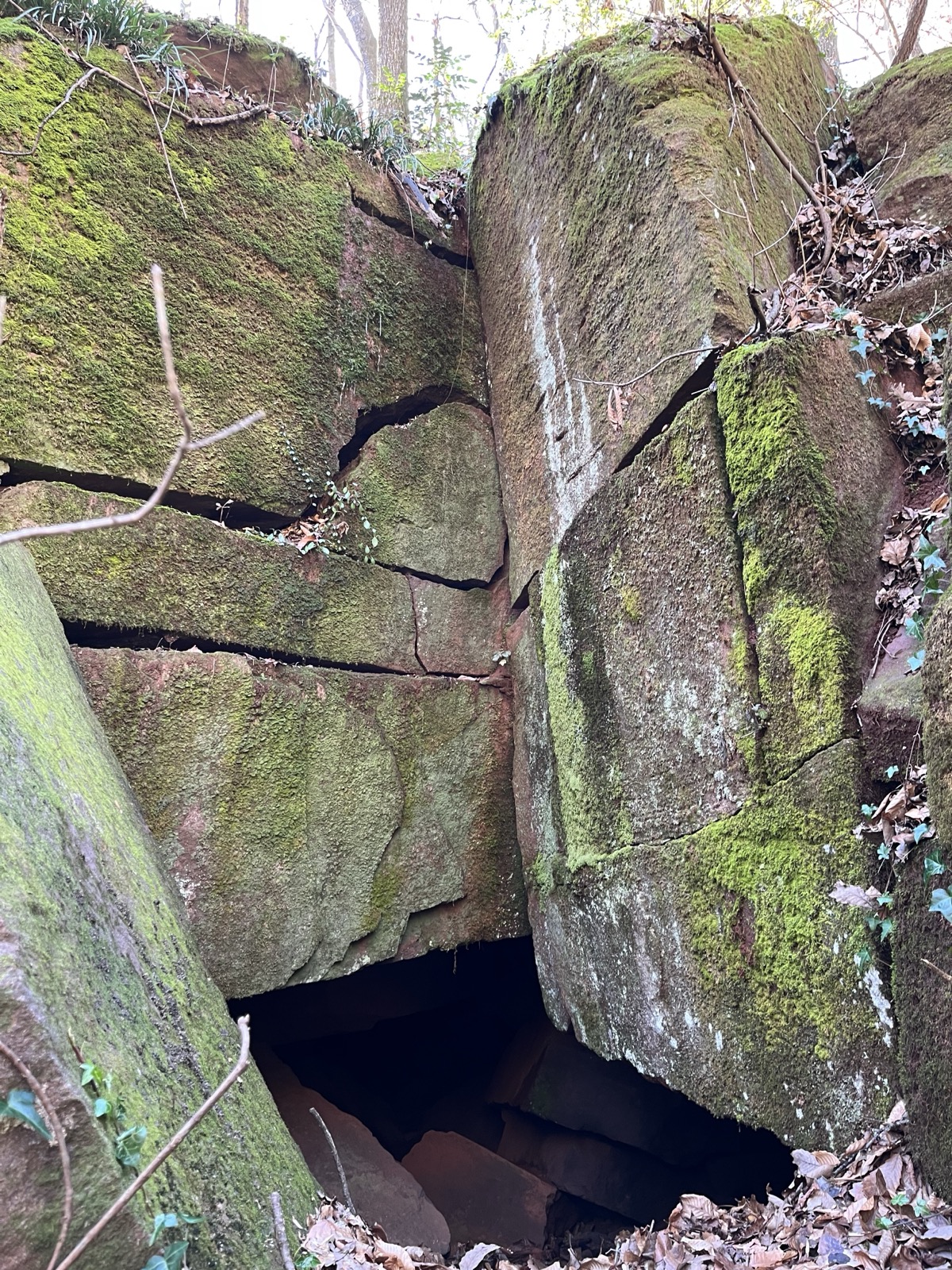
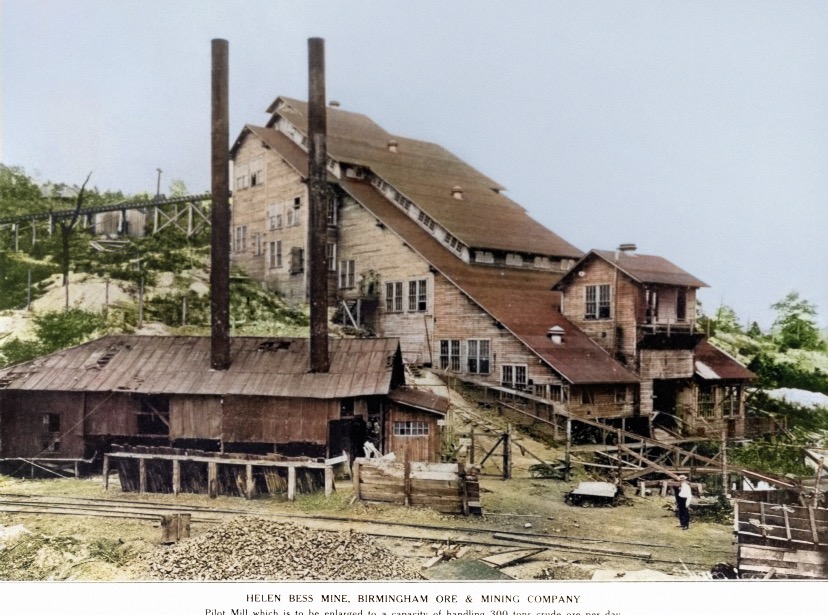
At the south end of the string sat Helen Bess, in the ravine behind today's Mountain Brook Post Office. It grew into a genuine mining village, with a commissary, bath houses, and forty company houses, and around 1913 it hosted a hundred-thousand-dollar ore concentration plant, the district's first serious attempt since the 1890s to make low-grade ore pay. Two of its drift mouths, filled with concrete, are still visible behind the homes at Blenheim Place, and the plant foundations can be found off Timberline Drive when the leaves are down. At the north end stood the Hammond mine, opened in 1906, whose main slope was eventually driven 2,500 feet into the mountain, to a point directly beneath the present intersection of Oporto-Madrid and Crestwood Boulevard. When it was abandoned in 1922, the crews "robbed the pillars" on the way out, pulling the very columns of ore that held up the roof. Yuill puts it plainly: the Hammond mine site is essentially located at the Century Plaza shopping mall. There is a mine under Century Plaza. The mining ran right up to the Eastwood Festival Center, too. A 160-foot McElwain-era drift ran into the ridge directly across from the center's main entrance, on the same property as the Hammond mine. Building the festival center in 1989 did destroy some of the old workings, but the ones it cut away were the tops of the Wilkomont and the adjacent Huron mines.
The mines are gone, but you can still trace the railroad that served them without knowing it. From Century Plaza the old Red Gap Branch grade runs along Cresthill Road, then parallels Montclair Road all the way to the rugby field, where it crosses. The ravines above Montclair are still scarred with drift mouths, inclines, and tram grades, invisible from the street but plain on a LiDAR scan. A furnace gave its name to a town across the mountain, a church that outlived it, an ore seam, and a daughter's ore seam beside it. The mining is a century gone. The mountain kept the receipts.
Sources: Robert Yuill, Iron Ore Mining on the Northeast Portion of Red Mountain, Birmingham, Alabama (2010) and "Iron Mining at the Ruffner Mines" (Alabama Geological Society 43rd Annual Field Trip, 2006). Barefield, Marilyn Davis. A History of Mountain Brook, Alabama & Incidentally of Shades Valley. Ernest F. Burchard, Iron Ores, Fuels and Fluxes of the Birmingham District (1910). Todd Russell, "Yankees in Crestwood, Crestline and Cherokee Bend," Jefferson Journal (2025).
Crestline Neighborhood Association · Local History Series