Zoning & Land Use Committee

What gets built in Crestline Park

The Zoning & Land Use Committee reviews the zoning cases, variance requests, and development plans that affect Crestline Park, and brings its findings and recommendations to the neighborhood at the monthly CNA meeting — so residents can vote with the facts in hand.

Committee reports are posted below as they are submitted.

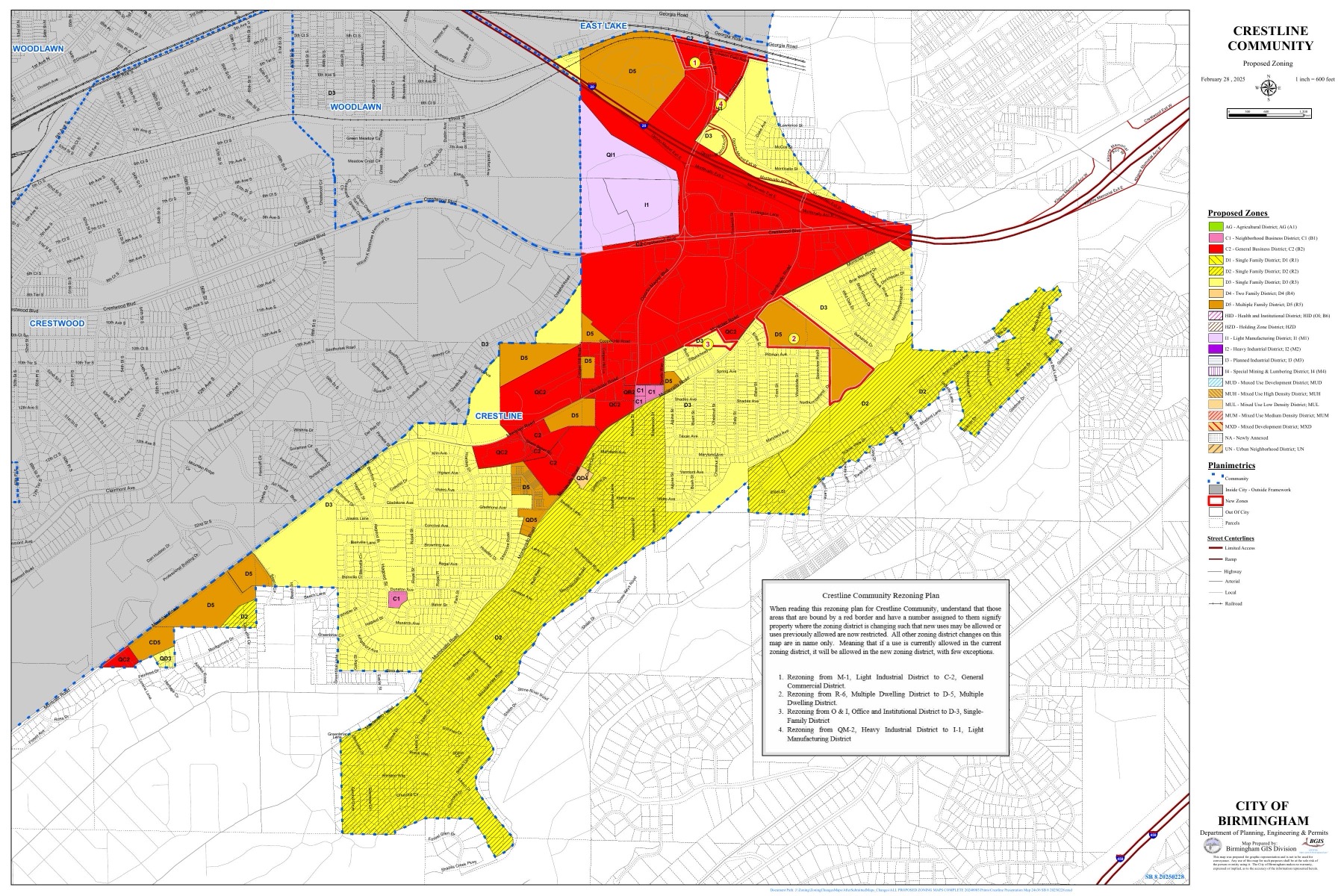
City of Birmingham proposed zoning map for the Crestline community, February 28, 2025
The City of Birmingham’s proposed zoning map for the Crestline community (SB 8, February 28, 2025). Tap the map to open the official full-size PDF.
Open the official map (PDF)
Chair
Josh Goodwin
Joshcgoodwin79@gmail.com
Member
John Trott
buildertrott143@gmail.com
Member
Caroline Bundy
carolinebundy@gmail.com
Member
David Burt
ukats22@gmail.com
Member
Amy McMullen
amcm100@yahoo.com
Member
Florence Renfroe
patrenfroe@outlook.com
City References

These open on the city’s own websites, which hold the current official documents.

Committee Reports
August 27, 2026

Preliminary Report — the St. Peter’s project at 605 Hagood Street: status of the required street improvements

Presented by Josh Goodwin, Committee Chair.

PRELIMINARY REPORT — August 27, 2026. The City’s responses to fifteen public records requests were due August 26. The committee was told verbally, at the counter, that the requests had been denied — without written notice, without itemization, and without any grounds stated. Written notice has since been requested under Ala. Code § 36-12-40. The City’s Office of Public Information is now searching for the waiver document directly. The closing paragraph of this report will state what was produced, or was not. Every quotation below is word-for-word from its source.

The short version: the City has confirmed in writing that the approved plan omits the curb, gutter, and storm sewer the regulations require — and no one, at the City or at the church, will name the document that makes that omission lawful.

Read the full report (PDF)
August 27, 2026

Southern Area Framework Plan — what the rezoning means for Crestline

The City of Birmingham is updating its zoning maps to carry out the Southern Area Framework Plan, and Crestline is included. On the city’s proposed map, Crestline Park’s residential lots change from R-3 to D-3. Both designations are the city’s “Single Family District” — the map’s legend lists each proposed district beside the current one it replaces (D-3 beside R-3), and the city’s own note on the map says the change is in name only: a use allowed today stays allowed under the new district, with few exceptions.

Correction, September 7, 2026: an earlier version of this notice, and the President’s remarks at the August 27 meeting, had the two labels reversed (“D-3 to R-3”). The City’s map is the source; the direction is R-3 to D-3.

As discussed at the August 27 meeting: for Crestline, there is nothing in this change for the association to oppose or support.

Our neighbors in Highland Park are in a harder spot. Their portion of the same plan proposes rezoning that would allow multi-unit buildings on a number of historic single-family properties, and the Highland Park Neighborhood Association is actively contesting it. The CNA supports Highland Park and their efforts.

The city’s proposed zoning map for the Crestline community is linked below. Highland Park’s portion of the plan sits on the neighboring Red Mountain community’s map, available with the full history on their rezoning page. Questions? Bring them to the monthly meeting, or contact the Zoning & Land Use Committee above.

City proposed zoning map — Crestline community, February 28, 2025 (PDF)